Contact Us    |   WVGES Home

Interactive Mapping

WVGES has a large number of interactive maps and Representational State Transfer (REST) web services. Please click or tap a map image below to go to the interactive map. For more information about a given map or application, please click or tap the READ MORE ... link. Other mapping, including printable maps, can be found here.

Oil and Gas Maps

West Virginia Oil and Natural Gas Wells

  • Links from oil and gas well points to extensive well information via the WVGES "Pipeline" and "Pipeline-Plus" applications
  • Ability to extract data to an MS Excel spreadsheet via the inquiry (i) tools
  • Data updated weekly
line

Lithostratigraphy of Middle and Upper Devonian Organic-Rich Shales in WV, RI-35

  • Revised stratigraphic terminology for some Upper Devonian units
  • from the peer-reviewed Reports of Investigation, RI-35
READ MORE ... for links to cross sections, well data, report text, and much more information
line

Marcellus Formation in West Virginia

  • Selected well-based layers* now automatically updating (weekly on Sunday evening)--*Completed Marcellus Wells, Permitted Marcellus Wells, Digitized (LAS) Logs, and Scanned (Raster) Logs
  • Link to additional data from API Number for Completed/Permitted Marcellus Wells and Wells with Digitized/Scanned Logs; view production data charts for Completed Wells
  • Introducing new tools-Bookmark, Query, Draw, Share
  • Improved navigation and screen control
READ MORE ...
line

Utica Shale Play (Regional Map)

REST Mapping Services for this map are at ... /arcgis/rest/services/Utica
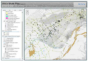
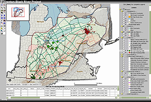
This play-based map features wells and ancillary data, including TOC, core, SEM, and thin sections, for the Upper Ordovician, Kope, Utica, Point Pleasant, Trenton, and Black River gas plays in Kentucky, New York, Ohio, Pennsylvania and West Virginia. This is the culmination of a two-year study. READ MORE ...
line

Appalachian Basin Tight Gas Plays (Regional Map)

READ MORE ...
line

Ordovician Trenton-Black River Formations (Regional Map)

An Appalachian Oil and Natural Gas Research Consortium (AONGRC) research project on these basin-wide plays featuring:
  • An integrated, multi-faceted, resource-assessment model of Trenton-Black River reservoirs in New York, Ohio, and West Virginia
  • An integrated structural-diagenetic-stratigraphic model for the origin of Trenton-Black River hydrothermal dolomite reservoirs
READ MORE ...
line

Coal Maps

West Virginia All Mining Map

REST Mapping Services for this map are at Coal_Web_Mercator/All_Mining_WM/MapServer
View general information pertaining to all underground, surface, auger and highwall mining within the state. This map features:
  • Inquiry results with hyperlinks to view a seam-specific detailed map showing all coal features
  • Ability to zoom to current location or geocode an address
  • Data updated periodically
READ MORE ...
line

Coal Bed Mapping Project Maps

REST Mapping Services for this map are at /Coal_Web_Mercator
About 80 coal beds arranged in stratigraphic order, these maps feature:
  • Links from mining layers to downloadable mine map images
  • Total, percent parting and net coal thickness
  • Polygons of underground and surface mining activity
READ MORE ...
line

Other Maps

Geologic Map of West Virginia   NEW!

REST Mapping Services for this map are at ... rest/services/Geology/Geologic_Map_of_West_Virginia_1968_rev_GeMS_2023/
Featuring Geology of the State READ MORE ...
line

A Geologic Transect Across West Virginia

Featuring Geology from Parkersburg to Harpers Ferry Along Some of Our Major Highways
  • 85 locations and images
  • Explore geology in a "story map" design
READ MORE ...
line

Topographic Map Index

REST Mapping Services for this map are at ... /arcgis/rest/services/Utica
Use this map to find and order paper topographic maps. READ MORE ...
  • 7.5 minute quadrangles
  • 15 minute quadrangles
  • 30 X 60 minute quadrangles
  • 1° X 2° quadrangles
line

WV Geothermal Map

  • Depths at specific temperatures
  • Temperatures at specific depths
  • Wells with temperature data
  • View data in relation to other geological features, infrastructure, development sites and more!
READ MORE ...
line
Page last revised February 13, 2024.
Please send web site questions, comments, or suggestions to webmaster.
WVGES address   
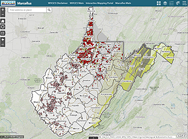
WV Geological & Economic Survey
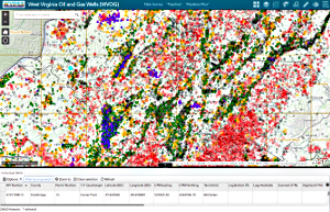
1 Mont Chateau Road
Morgantown, WV 26508
Phone: (304) 594-2331
Fax: (304) 594-2575
info@wvgs.wvnet.edu
fb icon

Valid XHTML 1.0!
WVGES Welcome Page
Welcome Page